Description
**This Item Ships From Vendor Direct**
North Carolina
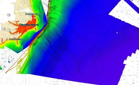
3D fishing and diving map
with high definition images of the seafloor.
**Preview map is LOW RESOLUTION. See gallery below for HD sample images**
- :
North Carolina fishing chart features high definition 3D images of the seafloor. - Location:
North Carolina 3D HD fishing chart coverage includes Virginia Beach, VA to the North Carolina/South Carolina border. The chart has coverage nearshore from Virginia Beach to Sunset Beach, including the Pamlico Sound, Cape Lookout Shoals, and Diamond Shoals. The chart has coverage of the Atlantic canyons including Pamlico Canyon, Hatteras Canyon, Hatteras Ridge, and Keller Canyon. - Fishing Map Size: Approximately 72,000 square miles of potential fishing spots.
- Depths: 0 ft to 17,000 ft
Reviews
There are no reviews yet.